Real-time location systems: BLE, UWB and where GPS stops
A real time location system tracks people and assets indoors, where GPS cannot. How BLE, UWB, Wi-Fi and RFID compare, what accuracy is honest and how to choose.
Asghar Ali · Chief Technology Officer, Kakushin.io LTD
A real time location system (RTLS) is a set of tags, fixed receivers and software that works out where people or assets are inside a building and keeps that position up to date, second by second. It exists because GPS needs a clear view of the sky and gives out under a roof. The main radio technologies are BLE, UWB, Wi-Fi and RFID, and they trade accuracy against tag cost, battery life and installation effort.
I have built one of these for a crowd-heavy site, where a workforce had to stay findable inside covered areas that satellites cannot see. This is the view from the architecture side: what each technology can honestly deliver, how to choose, and where these systems quietly fall over.
What is a real time location system?
An RTLS automatically identifies and tracks the location of tagged objects or people in near real time, inside a defined space. It has four parts:
- Tags worn by people or fixed to assets. They transmit a signal, usually on a fixed interval.
- Infrastructure: fixed receivers, readers or anchors at surveyed positions that hear that signal and time-stamp it.
- A location engine: software that turns those measurements into a coordinate, a zone or a room.
- Applications: the console, alerts, geofences and reports that people actually use.
Two words in the name matter. Real time means seconds, not a nightly report. Location can mean very different things: which building, which room, which metre, or which side of the same workbench. Agree which one you need before you look at products, because that choice drives almost every cost that follows.
Why does GPS stop working indoors?
GPS stops working indoors because satellite signals are weak by the time they reach the ground, and roofs, walls and floors block, absorb and reflect them. GPS.gov lists signal blockage by buildings, indoor or underground use, and signals reflected off buildings or walls ("multipath") as common causes of poor accuracy. It puts a GPS-enabled smartphone at about 4.9 m under open sky, and says accuracy worsens near buildings (GPS.gov: GPS accuracy, read on 2 November 2026).
Under a roof you often get no fix at all, or a stale one that drifts. GPS also cannot answer the two questions buildings ask most: which floor, and which side of this wall. That gap is what RTLS fills. I wrote up a hard version of it, where the busiest covered spaces on earth defeat GPS entirely, in tracking a workforce indoors at Hajj.
How do the main RTLS technologies compare?
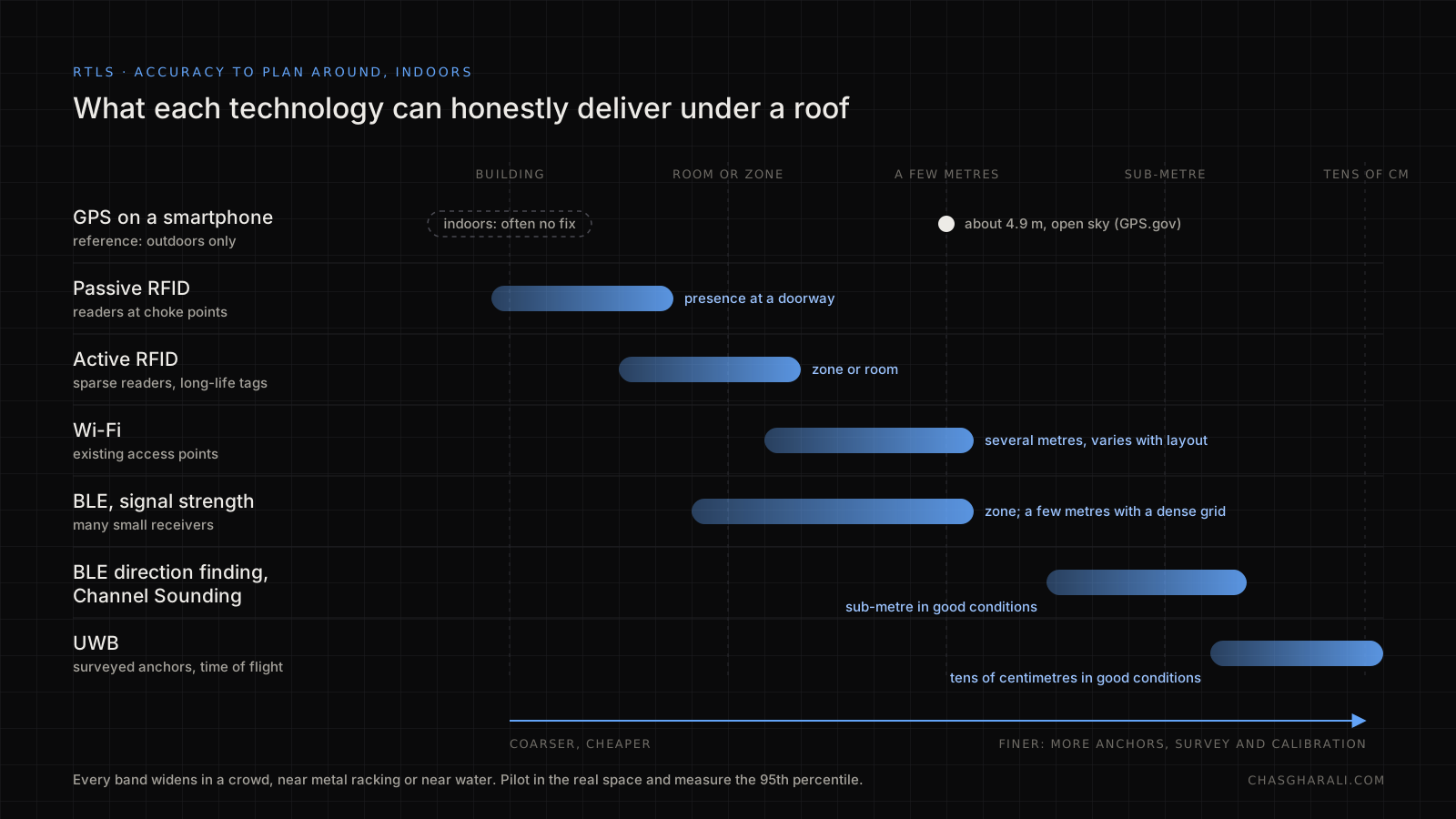
BLE is the usual starting point, UWB is the choice when you need decimetre accuracy, Wi-Fi reuses access points you already own at coarser accuracy, and RFID is cheapest for zone presence and choke points. The bands below are what to plan around, not guarantees. Every one of them gets worse in a crowd, among metal shelving or near water.
| Technology | Accuracy to plan around | Tags | Infrastructure | Best for |
|---|---|---|---|---|
| Passive RFID | A doorway or portal ("it passed here") | Very cheap, no battery | Readers at choke points | Stock and equipment through doors |
| Active RFID | Zone or room | Battery, long life | Sparse readers | Asset presence by zone |
| Wi-Fi | Several metres, varies with layout | Battery-hungry tags or phones | Existing access points | Coarse tracking, visitor flow |
| BLE, signal strength | Zone or room; a few metres at best with a dense grid | Cheap, small, long battery life | Many small receivers | People and assets, wearables |
| BLE direction finding or Channel Sounding | Sub-metre in good conditions | Cheap tags, newer chips | Antenna-array locators, or ranging-capable devices | Shelf or bay level on a BLE budget |
| UWB | Tens of centimetres in good conditions | Dearer tags, shorter battery | Anchors with a careful survey | Forklifts, safety zones, tools, sports |
Three standards are worth knowing by name:
- Bluetooth direction finding. Core Specification 5.1 (January 2019) added Angle of Arrival (AoA) and Angle of Departure (AoD), so a receiver with an antenna array can measure the direction a BLE signal comes from, not only its strength. The Bluetooth SIG says positioning systems built on it can reach centimetre-level accuracy (Bluetooth SIG: direction finding).
- Bluetooth Channel Sounding. Core 6.0 (August 2024) added secure distance measurement between two devices. The SIG says early implementations show about ±20 cm, and up to 150 m of range when both devices transmit at maximum power (Bluetooth SIG: Channel Sounding, read on 2 November 2026). It measures distance between a pair, so a location engine still has to combine several of them into a position.
- UWB ranging. IEEE 802.15.4z-2020 enhanced the ultra-wideband physical layers and added features to improve the integrity and accuracy of ranging (IEEE 802.15.4z-2020). The FiRa Consortium, which certifies UWB interoperability, explains that UWB's 500 MHz channels and pulses of about 2 ns are what make centimetre ranging possible (FiRa: how UWB works).
There is also an ISO/IEC 24730 family for RTLS air interfaces and the application programming interface, with parts for 2.4 GHz and UWB systems. It standardises the interfaces, not how a location is calculated, so it tells you little about accuracy (Real-time locating system, standards section).
How do BLE and UWB actually find a position?
They measure something about the radio signal, then solve for a position. The measurement method matters more than the logo on the tag.
- Signal strength (RSSI). A weaker signal suggests a longer distance. It is cheap and works with any BLE tag, but bodies, walls and the angle of the tag move it by large amounts, so it is noisy.
- Fingerprinting. Survey the building, record the signal pattern at known points, then match live readings to that map. It is more accurate than raw RSSI, but the map decays every time shelving or furniture moves.
- Angle of arrival. An antenna array measures the direction of the signal. Two or more locators give an intersection. It needs the array hardware.
- Time of flight. Measure how long the signal takes, either as a round trip or as the difference in arrival time at several anchors. This is how UWB gets centimetre-class ranging: its very short pulses make the timing precise.
The Hajj system used signal strength, and it taught me the main lesson about RSSI. The 2.4 GHz band is absorbed by water and a person is mostly water, so a band held across the chest can lose tens of decibels against the same band held out to the side, which looks like a long move. The output therefore was never a coordinate. It was a zone with a confidence: the receiver that heard a band strongest over a time window, with hysteresis so someone standing on a boundary did not flicker between sections. That answered the supervisors' real question, "which section is this marshal in?", and it was honest about what the receiver density could support.
Where is RTLS used?
RTLS is used wherever someone needs to find a person or a thing indoors faster than walking round and looking. The common cases:
- Hospitals: finding wheelchairs, pumps and beds; staff duress alerts.
- Warehouses and factories: work-in-progress tracking, tool and pallet location, forklift-to-pedestrian proximity warnings.
- Crowd and event operations: keeping a workforce findable in covered areas, as at Hajj.
- Mining, tunnels and plants: mustering and "who is still inside" counts.
- Offices and labs: shared equipment and room occupancy.
Each of these needs a different accuracy, which is the next question.
How accurate is accurate enough?
Accuracy is enough when it is smaller than the decision you make with it. Write the decision first, then derive the requirement.
| Decision the position feeds | Accuracy needed | Likely technology |
|---|---|---|
| Is this asset in the building at all? | Building | Passive RFID at doors, Wi-Fi |
| Which department or room? | Room | Active RFID, BLE signal strength |
| Which bay or shelf? | 1 to 3 m | BLE with a dense grid, BLE direction finding |
| Is a person inside a danger zone? | Under 0.5 m, with guarantees | UWB, plus independent safety systems |
Ask for the update rate and latency too. A tag that reports every 30 seconds will not drive a live proximity alert, however accurate its coordinates are. In the Hajj system the advertising interval was the one tuning parameter that mattered: shorter means a fresher position and a shorter battery life, and the right value came from the operations team, not from engineering alone.
A worked example (illustrative): a hospital wing wants to find 200 wheelchairs and infusion pumps. Room level is enough, because a nurse only needs to know which room to walk to. One BLE receiver per room or corridor segment, with zone logic like the one above, fits the job. Putting UWB anchors on every ceiling would buy accuracy nobody uses. A warehouse where a forklift must slow when a person is within 2 m is a different problem: that needs UWB or equivalent ranging, and a safety review that does not treat the RTLS as the only safeguard.
What does a deployment really cost, and where does it break?
Tags are the smallest part of the cost. The money and the risk sit in infrastructure, survey, power, calibration and the operating process around the tags. The failures I plan for:
- The radio environment. Crowds, metal racking and water absorb or reflect signals. Test in the real space at its busiest, not in an empty hall on a Sunday.
- Battery logistics. Thousands of tags that need charging or new cells are an operational process. Decide who swaps them, and how the system reports a low battery, before you buy.
- Power and network to every receiver. Cabling each anchor often costs more than the anchor.
- Map drift. Fingerprinted maps age as layouts change. Budget for periodic re-survey.
- Silence. A tag that stops reporting could have a flat battery, be in a shielded corner, or belong to someone who went home. Decide what the console shows for "not heard from in ten minutes", because that is the state supervisors act on.
- Privacy and consent. Tracking people is personal data processing. The UK ICO's guidance on monitoring workers covers the lawful basis, fairness, transparency to workers and when a data protection impact assessment is needed (ICO: monitoring workers; the ICO notes it is under review after the Data (Use and Access) Act, read on 2 November 2026).
The back end matters as much as the radio. Position updates are frequent, small and tolerate the odd loss, so a lightweight publish/subscribe layer suits them; see MQTT: designed for the network that isn't there. Turning raw readings into zones close to the receivers, rather than in a distant server, is the placement argument fog computing makes. Supervisor apps used on the floor also need to cope when signal drops, which is the problem offline-first requests in the browser is about.
How do I choose an RTLS?
Choose by working backwards from the decision, then prove it on site. The method I use:
- Write the decision each position feeds, with the accuracy and latency it needs.
- Count tags, floor area and floors, and estimate tag life and the effort to keep tags charged.
- Shortlist the cheapest technology that meets the accuracy. Resist upgrading "just in case".
- Pilot in the worst part of the real space, with real crowds, real racking and real people wearing the tags the way they actually will.
- Measure error against surveyed ground-truth points and report the median and the 95th percentile, not the vendor's best case. If zones are 4 m wide and the 95th-percentile error is 3 m, you will mislabel people near the edges, so either widen the zones or add receivers.
- Settle privacy and retention before you collect anything: who can see positions, for how long, and what workers are told.
If you want a second opinion on a proposed design or a vendor's accuracy claims, BLE indoor positioning is part of the IoT work on my hire page.
FAQ
What is a real time location system?
A real time location system is tags, fixed receivers and software that continuously calculate where people or assets are inside a building. It does the job GPS cannot do under a roof, and its accuracy ranges from room level to tens of centimetres depending on the technology and the site.
What is the most accurate RTLS technology?
Ultra-wideband (UWB) is generally the most accurate radio option, often tens of centimetres in good conditions, because it measures signal timing very precisely. Bluetooth Channel Sounding and direction finding narrow the gap. UWB costs more per tag and anchor and needs a careful installation survey.
Is BLE good enough for indoor tracking?
For room or zone level, yes, and that covers most people and asset tracking. Signal-strength BLE is noisy around bodies and metal, so plan for zones rather than coordinates. Direction finding and Channel Sounding can reach sub-metre, but they need newer hardware and should be proven in a pilot.
Can I use Wi-Fi for RTLS?
You can reuse existing access points for coarse positioning, usually several metres. It is attractive when the infrastructure is already there, but Wi-Fi tags are battery-hungry and accuracy varies a lot with layout, so measure it in your own building before relying on it.
Is tracking staff with RTLS legal?
Often, but not automatically. In the UK you need a lawful basis, a clear and proportionate purpose, honest notice to workers and limited retention, and usually a data protection impact assessment first. The ICO's monitoring guidance is the place to start; take advice before a rollout.
Sources
- GPS.gov: GPS accuracy, read 2 November 2026
- Bluetooth SIG: Bluetooth direction finding and Bluetooth Channel Sounding, read 2 November 2026
- IEEE 802.15.4z-2020: enhanced UWB physical layers and associated ranging techniques
- FiRa Consortium: how UWB works
- ICO: Employment practices and data protection, monitoring workers, read 2 November 2026
- Wikipedia: Real-time locating system, for the ISO/IEC 24730 series