Prototype · October 2026
Civil–military air traffic coordination: one picture, one plan, and an answer in seconds.
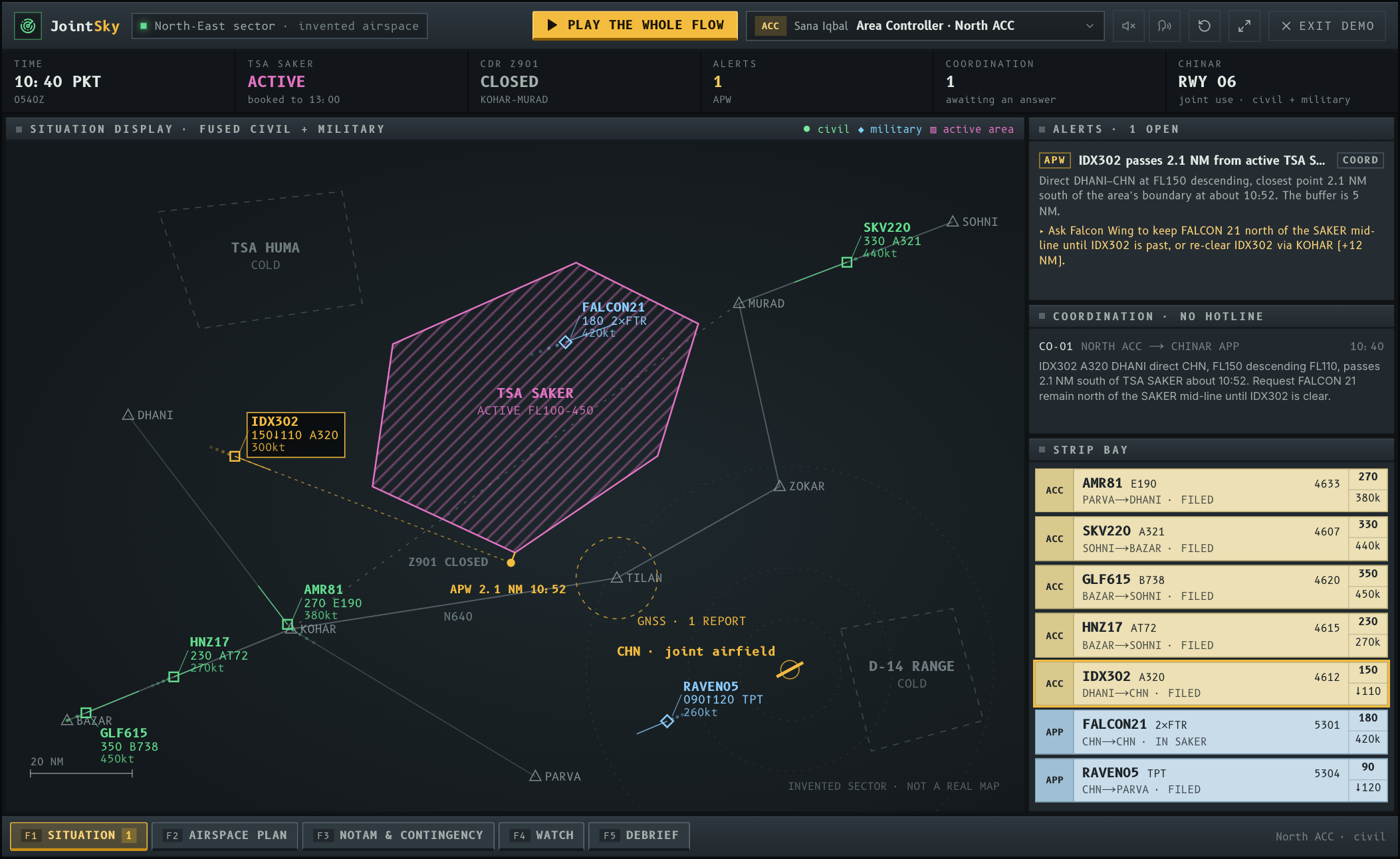
Pakistan’s sky is shared. Military controllers at air bases — some of them used by civil flights too — and civil area controllers work the same airspace from different screens, and the public record of the last seven years is one of closures, monthly NOTAM renewals, lost overflight revenue and systems overdue for replacement. This is a working prototype of the layer between the two sides: a fused picture, a shared airspace plan on the ICAO and EUROCONTROL Flexible Use of Airspace model, conflict look-ahead, coordination by message, NOTAMs and the controllers’ watch. It runs in your browser on an invented sector, and the guided run performs every step as it explains it.
The context
The cost of a sky that two systems share.
Air traffic services in Pakistan are being reorganised: the old Civil Aviation Authority is being split into a regulator, the Pakistan Civil Aviation Authority, and a service provider, the Pakistan Airports Authority, which runs the area control centres at Karachi and Lahore. The Pakistan Air Force controls its own traffic at its bases, and military training needs large blocks of airspace that civil routes have to go round.
None of that is unusual — most countries share their sky this way. What the Flexible Use of Airspace concept adds is the discipline of treating airspace as neither civil nor military, booking it only for as long as it is used, and making the hand-over between the two sides fast enough to be worth doing. That needs software both sides trust, more than it needs new radars.
The limitations
Six problems the public record shows.
Taken from public reporting only. Nothing here describes the Pakistan Air Force’s internal procedures, which are not published; where a source is old or second-hand, it says so.
Two pictures of one sky
Military controllers at an air base and civil area controllers each work from their own radar and their own flight data. When a civil flight passes near an active military area, the two sides have to compare notes before either can act.
Airspace held longer than it is used
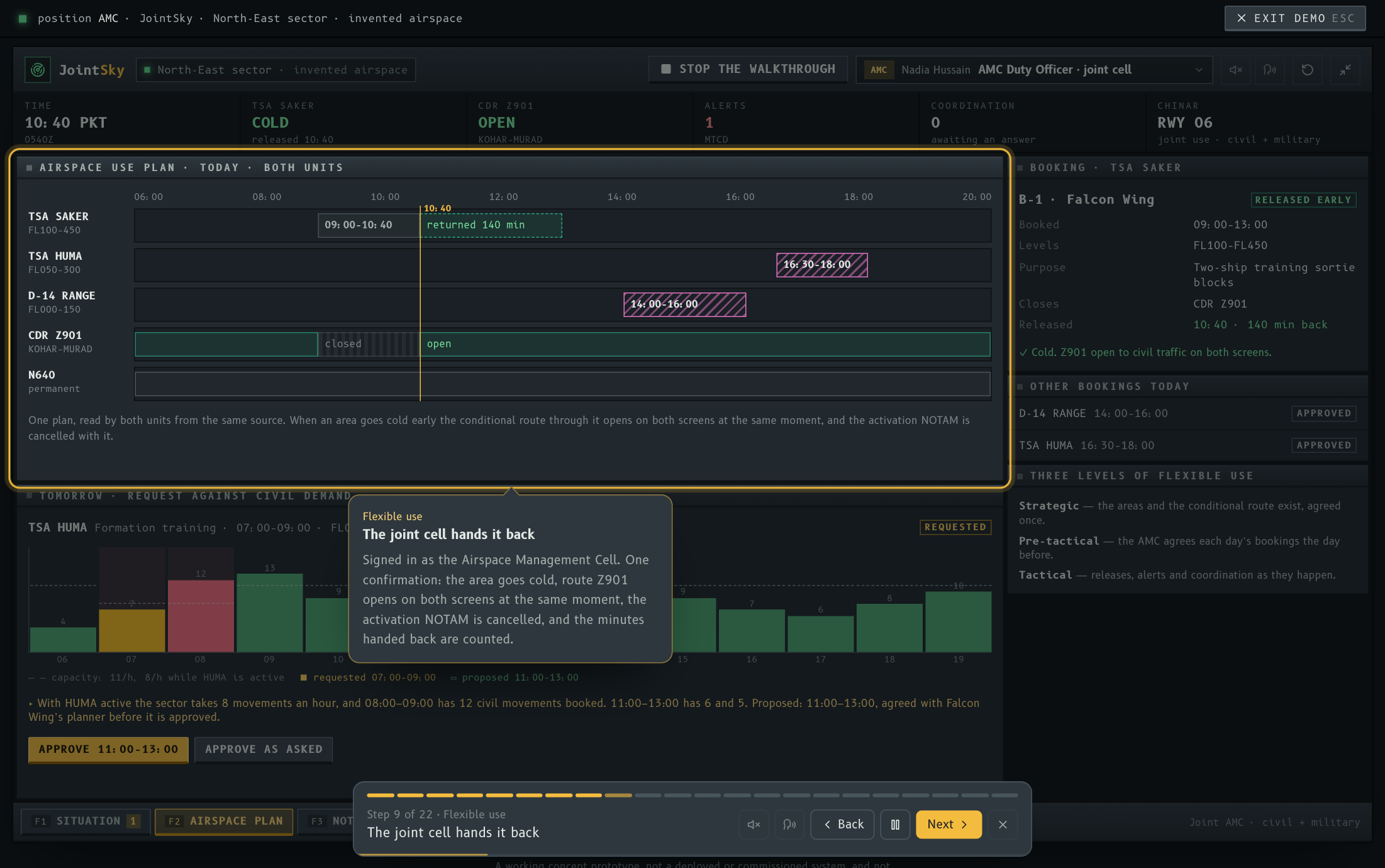
Training areas are booked in blocks. When a sortie ends early the area usually stays closed until the booking runs out, because handing it back takes calls and paperwork, and civil flights keep flying round it.
Closures that are costly and recurring
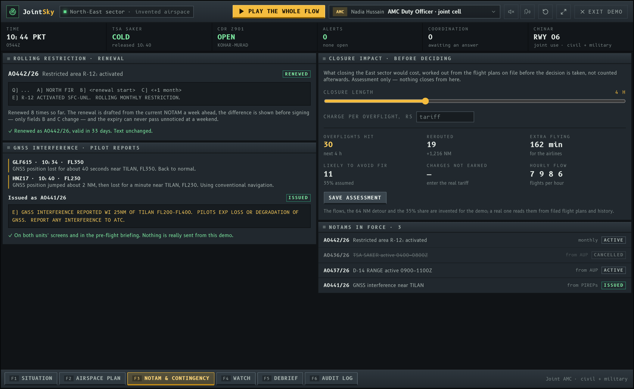
The 2019 closure lasted almost five months; the restriction in force since April 2025 has been renewed by NOTAM every month. Each renewal is a manual task with a hard deadline, and each closure has a cost that is counted afterwards.
Ageing systems, upgrades under way
The Karachi and Lahore area control systems were described in 2022 as almost twelve years old; their replacement was approved that year and a larger air traffic management project reached technical bids in September 2026.
People on long spells
As long ago as 2012 the controllers’ international federation relayed complaints from Pakistan of controller shortages, fatigue and missed refresher training. No current figures are public, which is itself a reason to measure them.
Interference nobody owns
India’s government reported 465 GNSS spoofing incidents in the border region between November 2023 and February 2025. Pilot reports of lost satellite navigation need to become an advisory quickly, on both sides of any boundary.
What it adds
Software between the two units, not instead of either.
The system predicts, proposes and records. A controller decides, and the other unit agrees to anything that touches its airspace.
One fused picture.
Civil flights from the area radar and military flights from the airfield’s approach radar on one display, with the day’s active areas and routes drawn as the plan has them — so both units argue from the same facts.
Coordination by message, timed.
A request to the other unit is a structured message — which flight, where, when, what is asked — answered with one key. It replaces the hotline call for the routine cases, and the log records who agreed to what, in how many seconds.
Flexible use of airspace.
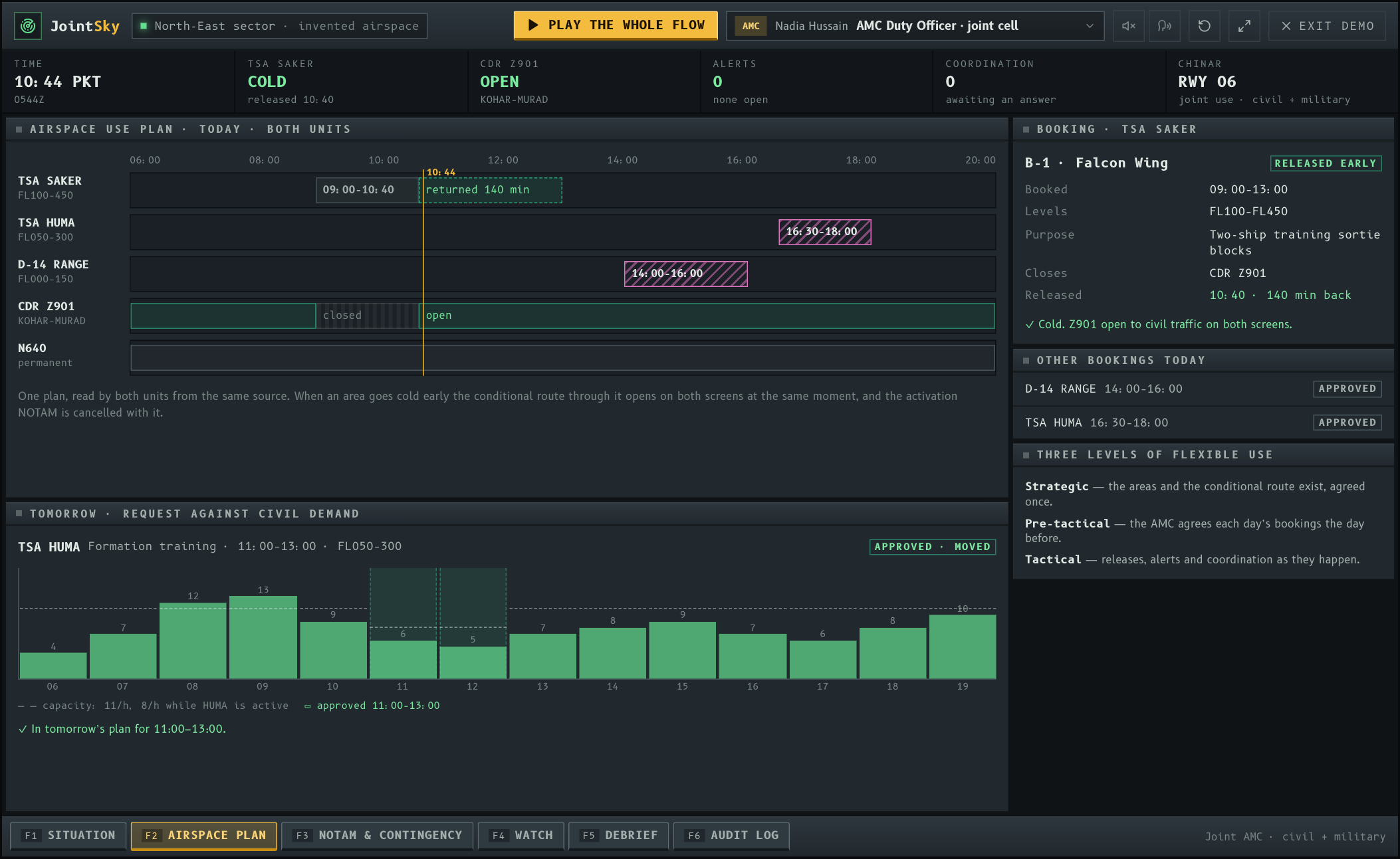
The day’s Airspace Use Plan is one timeline both units read. The military unit releases an area the moment it is finished; the joint cell confirms; the conditional route through it opens on both screens and the activation NOTAM is cancelled with it.
The released area is used.
Every civil flight that still gains from the released area is offered the shorter route at once, and the distance, time and fuel saved are counted — the figure that makes the case for releasing early.
Look-ahead on shared runways.
Medium-term conflict detection checks military and civil traffic together — fighters returning to a joint-use airfield and an airliner landing there — and proposes a sequence that Approach agrees with one key.
Tomorrow, settled today.
A booking request is checked against civil demand hour by hour before it is approved. A clash with the morning peak is moved the day before, with the military planner’s agreement, not argued on the frequency.
NOTAMs that cannot lapse.
A monthly restriction is redrafted from its current text a week ahead with only the dates changed; two pilot reports of lost GNSS near one point become a drafted advisory. A person signs both.
The watch, in the open.
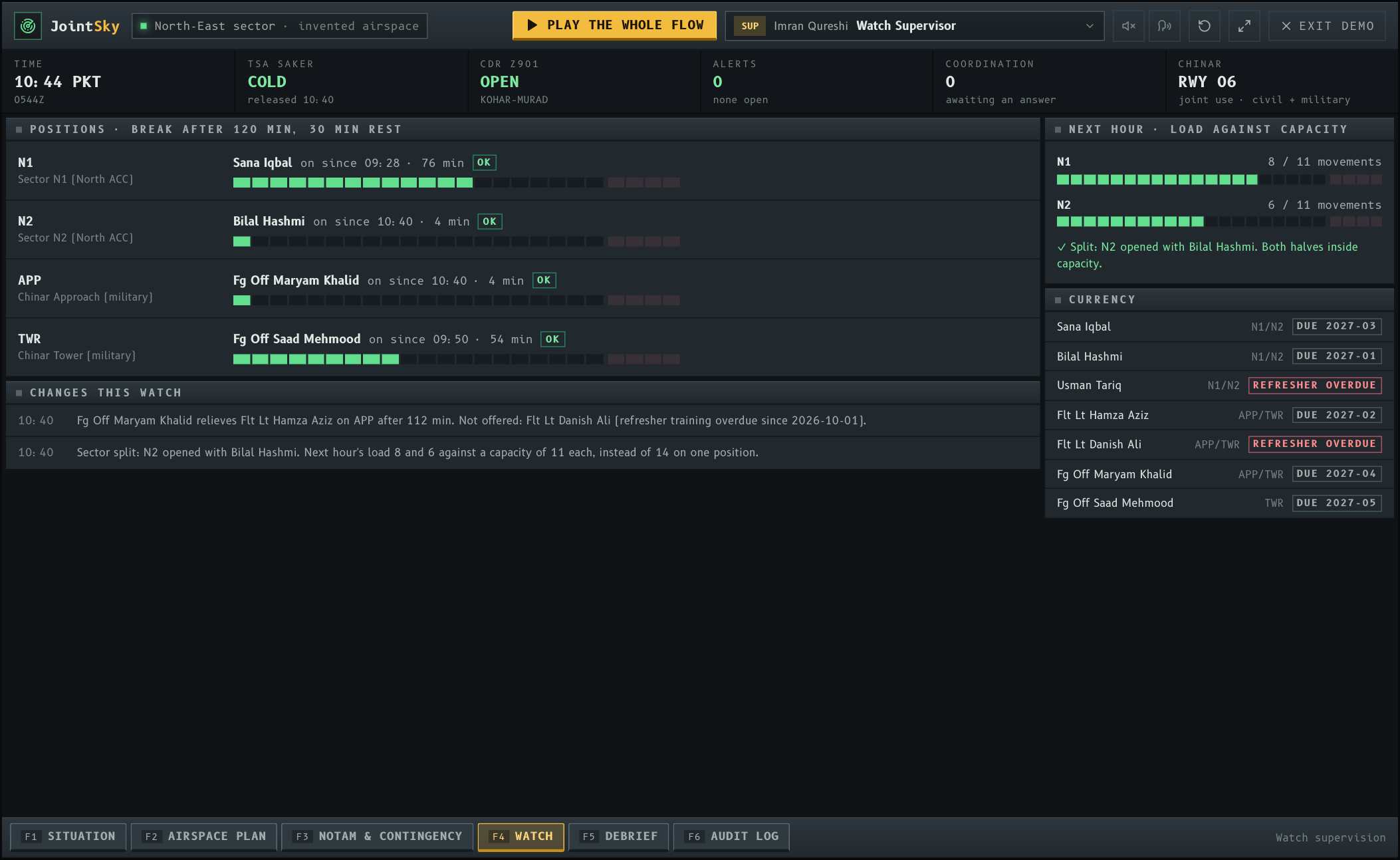
Time on position against the unit’s limit, who may relieve whom and why the others may not — endorsement, rest, refresher training — and sector load against capacity, with the split proposed before the overload.
The guided run
One morning in an invented sector.
Twenty-two steps across four seats: a proximity warning settled by message; a training area handed back more than two hours early and three civil flights re-cleared through it; fighters and an airliner sequenced onto one runway; two pilot reports turned into a GNSS advisory; a monthly NOTAM renewed in time; a closure costed before deciding; a controller relieved and a busy sector split. Every step performs the real action, and it reads itself aloud unless you turn that off.
Plan and notices
The day before, and the paperwork that cannot be late.
Proof
Measured in airspace returned and minutes saved.
A pilot of this kind is judged on what an airline, an air base and a regulator would each sign: airspace used rather than held, distance not flown, coordination that took seconds, and nobody past the limit on position — against a month of today’s way of working, measured first.
- Airspace returnedMinutes of military airspace released before the booking ended, and how many civil flights used them
- Distance and fuelTrack miles and fuel saved through released areas, by day and by route
- CoordinationRequests by message versus by telephone, and the time to an answer
- AlertsRaised, resolved before the predicted time, and false — counted by kind
- NOTAMsRenewals signed before expiry; advisories issued from pilot reports
- The watchSpells over the limit on position, refresher training overdue, sector overloads
Roadmap
Ninety days, one area, then a decision.
Both units, one table
Sit with the military ATC unit, the civil area control centre and whoever plans airspace between them. Read the letters of agreement, log a month of coordination calls and early-finished bookings, and agree the three things worth fixing first.
Shadow mode
Feed the prototype read-only copies of recorded surveillance and flight plans. It raises alerts and proposals on yesterday’s traffic alongside the real log; nobody is controlled by it, and every false alert is counted.
One area, one route, one airfield
Live trial on a single training area, its conditional route and one joint-use airfield, with the joint cell using the plan board and both units using messages for the routine cases. Then measure against the baseline and decide.
Architecture
How it would be built.
Read-only first
Surveillance and flight data arrive as copies; the system never sends a clearance, a transponder code or anything to an aircraft. It proposes, records and coordinates. Controllers control.
Need-to-share, not share-everything
Military mission data stays on the military side. Civil positions see a military track’s position, level and the status of an area — what separation needs — and nothing about the mission.
On premises, separable
Deployable inside each organisation’s own network, with a one-way or tightly filtered link between civil and military halves, tamper-evident logs and role-based access per seat.
Standard shapes
Airspace and routes modelled on AIXM, flight data on the usual message formats, NOTAMs in their standard fields, and the plan board on the ICAO and EUROCONTROL Flexible Use of Airspace concept — strategic, pre-tactical, tactical.
Alongside, not instead of
It sits beside existing radar and air traffic management systems, including any new ones being procured. If it stops, both units carry on exactly as they work today.
Every action attributed
An append-only log of every prediction, request, answer, release, approval and relief — what a safety investigation or a fatigue audit asks for later.
Safety and security
Safety case first, then service.
Air traffic software earns trust slowly, and should. Nothing here would be used to control traffic until it has run in shadow mode, been assessed against the hazards it could introduce, and been accredited by the people who own the networks it sits on.
Safety case before service
A hazard analysis and safety case under the regulator’s safety-management rules, and the shadow-mode results as evidence, before any controller relies on it.
Civil–military cooperation
The working model follows ICAO’s published guidance on civil–military cooperation in air traffic management and on flexible use of airspace; the letters of agreement between the units stay the authority.
Security accreditation
Hosting, the link between the two halves and every account reviewed by the organisations’ own security staff; no cloud dependency required.
People decide
No proposal takes effect until a controller accepts it, and anything that changes the other unit’s airspace needs that unit’s answer.
Scope
What this is, and what it is not.
- It is a concept prototype built from public reporting and published international guidance. It is not a deployed or commissioned system, and it is not affiliated with, endorsed by or built for the Pakistan Air Force, the Pakistan Airports Authority or the Pakistan Civil Aviation Authority.
- The sector, the joint airfield, the training areas, the routes and waypoints, every callsign, aircraft, booking and person are invented. Nothing reflects a real unit’s layout, procedures, frequencies or traffic.
- No public source describes the Pakistan Air Force’s own air traffic control procedures, and none were assumed: the workflows follow the general ICAO and EUROCONTROL model.
- It holds no data: state lives in the visitor’s browser and never leaves it. Nothing is ever sent to an aircraft or a NOTAM office.
- The figures on the debrief are counted from the demo run on invented traffic; the detour, flows and avoidance share in the closure calculator are invented too. A real pilot measures a baseline first.
Sources for the facts above
- About CATI: the Civil Aviation Authority split into a regulator and the Pakistan Airports Authority — Civil Aviation Training Institute
- Pakistan lifts ban on Indian flights, opens airspace closed since Balakot airstrike — Business Today, 16 July 2019
- Pakistan extends airspace ban on Indian flights (NOTAM A476/26, 16th extension) — ProPakistani, August 2026
- Pakistan lost Rs 4.1 billion after airspace ban on Indian flights: report — The Tribune (PTI, citing Dawn), August 2025
- Upgradation of air traffic control system at two main airports to cost Rs 3.396 billion — ProPakistani, September 2022
- PAA completes technical bid opening for Karachi, Lahore air traffic project — ARY News, September 2026
- Air traffic control working conditions in Pakistan a threat to air safety (IFATCA, 2012) — ATC Network
- What is GPS spoofing (465 incidents in the border region, Nov 2023 – Feb 2025) — WION
- Flexible Use of Airspace — SKYbrary
- Civil-military cooperation, ASM and FUA: LARA — EUROCONTROL